Cedar Breaks National Monument
Nick Christenson
September 5, 2007
Southwestern Utah is home to some of the most spectacular geologic formations
in the world. Overshadowed by its neighbors, Bryce Canyon National Park and
Zion National Park, Cedar Breaks National Monument is still a spectacular
sight. I have heard it described as a "mini Bryce Canyon". However, even
though it occupies a smaller footprint than Bryce, there is nothing "mini"
about this place.
Location
Cedar Breaks National Monument is located just east of Cedar City, UT.
Cedar City is about a 3 hour drive from Las Vegas along Interstate 15.
From Cedar City, one heads east on state highway 14, which is the same
route one takes to get to Bryce Canyon. 20 miles east of Cedar City,
turn north on route 148 into Cedar Breaks. Route 148 winds all the way
through the monument. North of the monument, one can take scenic route
143 west through Bryan Head to return to I-15 at Barowan.
Cedar Breaks National Monument is at considerable elevation. Pretty much
all of it is above 10,000 ft. above sea level. In this part of Utah,
that means snow, as much at 15 ft. of it per winter. Consequently, Cedar
Breaks is not open all year round. Typically route 148 and the park is
closed from about mid-October to mid-March, depending on the weather.
Near these times of year, definitely call the park before making the trip.
Plenty of good information is available at the
National Park Service web site.
Background
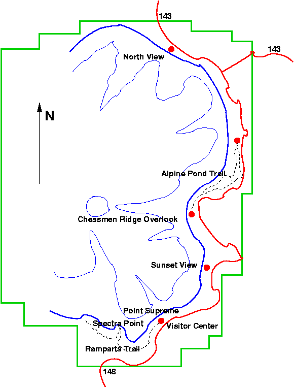
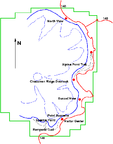 Several descriptions and pictures are available regarding Cedar Breaks,
but none of them gave me a very strong impression about what I was going
to see. The National Park Service web site has a good map as far as
navigation and services go, but it didn't leave me with a sense of what
the park would be like. A small map is included here, and a larger,
clickable version of the same map can be found toward the bottom of the
page.
Several descriptions and pictures are available regarding Cedar Breaks,
but none of them gave me a very strong impression about what I was going
to see. The National Park Service web site has a good map as far as
navigation and services go, but it didn't leave me with a sense of what
the park would be like. A small map is included here, and a larger,
clickable version of the same map can be found toward the bottom of the
page.
The park and all of its services exists at the top of what is called the
Markagunt Plateau. To the west, the plateau falls off rapidly basically
in a semi-circle forming an amphitheater partially bisected by several
ridges. If the park were a clock, the escarpment edge runs from about
12 o'clock down to about 7 o'clock, with the clock face depressed compared
to the raised area to the east of the edge. The road through the
park runs along the edge of the escarpment at the top of the plateau,
offering several spectacular views over the edge as one looks west.
Cedar Breaks is at 10,000 ft. of elevation, so it doesn't take too much
exertion for even a person is good shape to start to feel it. There aren't
any long hiking trails here, the longest being less than 1.5 miles one-way,
but unless you're used to this altitude, take frequent rests. Also, even
though it may be comparatively cool at this altitude, because there's less
air protecting you than there is in the desert below, skin will burn more
easily. During most of the time that Cedar Breaks is open, sunscreen is
recommended.
Also, Cedar Breaks gets considerably more precipitation than the surrounding
lowlands, and much more than the Mojave Desert to the south and west. The
hiking trails and some of the paths leading to scenic overlooks are not
paved, so getting some muddy shoes is a possibility. If one doesn't plan
to do any hikes and it hasn't rained recently, this shouldn't be a big
problem, but I still would bring along a pair of shoes that one doesn't
mind getting a little dirty.
Visiting the Park
After turning north on to route 148, we begin to gain altitude rapidly.
From temperatures of 95 degrees back on the freeway and 90 on highway 14,
the temperature drops quickly as I approach the park. It was about 60
degrees during the afternoon while I was up on the plateau, and very
windy. A stark change from the weather during the drive to Cedar City
from Las Vegas.
Late season monsoonal rains were threatening, and there was water on the
ground in a few places from the previous day. The clouds were cumulus
and very fast moving due to the high winds, but I got lucky. No rain
hit while I was up there. The clouds did play havoc with the light
though, as one will see in various photographs.

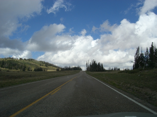
The terrain here is typical of alpine forests, mostly conifers but some
birch trees as well. Here's a thumbnail of the road way as I head toward
the park entrance. Click on the photo to see a larger view.
Pull over on the west side of the road as one enters the park to pay at
the fee station. Park here and take an easy walk to Point Supreme
to view the canyons to the west. One can also walk just over a half
mile west to Spectra Point, and just under a mile further to another
overlook along the Ramparts Trail. From Spectra Point west the trail
drops over 300 feet. This may not seem like a big drop amortized over
a mile, but remember, you're at altitude and you have to climb it on
the way back.
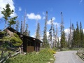 Also at the first stop is the visitor center, a small cabin with the usual
souvenirs. The accouterments at Cedar Breaks aren't nearly as grand as
they are at more popular siblings Zion and Bryce, but they're certainly
civilized. Here is a clickable view of the visitor center, facing east.
Also at the first stop is the visitor center, a small cabin with the usual
souvenirs. The accouterments at Cedar Breaks aren't nearly as grand as
they are at more popular siblings Zion and Bryce, but they're certainly
civilized. Here is a clickable view of the visitor center, facing east.
Point Supreme Photographs
The plateau through which the road runs is flat in places and slightly
hilly in places, although the slopes on top of the plateau are nothing
like the slopes one finds just a few hundred feet to the west of the
road. The area along the road is lightly wooded and could pass for,
say, the rolling hills of Vermont or Appalachia, but this illusion is
quickly dispelled on those occasions when one gets a clear look west.
The next stop on the tour is about a mile further north at Sunset View.
This is so named because it's a view straight west over the edge of
the plateau. I was there in the early afternoon, so I didn't get
to see it's namesake in action, but I'm willing to bet it would be
pretty spectacular. Because photographs would be taken into the sun,
though, I expect that the window for taking good pictures would be
short lived.
The drop-off of the plateau is steep (obviously) and deep (less so).
The drop to the floor of the amphitheater is in excess of 2200 feet.
Compare this to Bryce Canyon, where the maximum drop-off is in the 1500
feet range and we find a 900 foot drop at the main amphitheater.
Sunset View Photographs
The next stop is Chessman Ridge Overlook, named for the way the "hoodoos"
look as one gazes down into the canyons. For some reason, the water carved
"statues" that are signatures of this place (as well as Bryce Canyon) are
called hoodoos. This seems to date back to the days of the early Mormon
settlers in the area.
One thing to note, all of the photographs referenced on this page that
show geology are taken by pointing the camera down, sometimes at a
significant angle. The sense of depth is difficult to appreciate in a
two-dimensional medium.
Chessman Ridge Overlook Photographs
This stop is also the southern edge of the Alpine Pond Trail that
winds its way north to the next stop, Alpine Pond, naturally enough.
It's about 1 to 1.5 miles between the two stops, about 2.5 miles to
hike the trail round trip. A few hundred feet north of the Chessman
Ridge Overlook stop, the trail branches into two separate trails, the
lower trail, which is closer to the escarpment, and the upper trail,
which is closer to the road. The lower trail looks more difficult,
but I expect it is more scenic. If one were to travel only one (for
example, with the intention of going one-way and meeting up with
fellow travelers and transportation at the next stop), I think I'd
recommend the lower trail for the view. These trails aren't technically
difficult hikes, but they aren't easy walks either. They can require
some scrambling around, and they can be quite muddy in wet weather.
Near where the lower and upper trails diverge are some bristlecone
pines that are worth checking out; an easy walk from the parking
area.
Bristlecone Pines and the Alpine Pond Trail
At the north edge of the park is, naturally enough, the North View
of the canyons. Picture taking here is probably best in the early
morning and second best in the late afternoon, but I was there in
early afternoon, so there was only so much I could do. The views
are still spectacular at any time of day, though.
North View
Conclusion
While one could spend all day and then some at a place such as Bryce
Canyon, Cedar Breaks is good for anywhere from two hours to a half
day. The roadway that runs through the park is probably only 5 miles
long, there aren't any more than 3 miles of hiking trails, and there
are only five stops along the road. Further, it's tough to get a good
view from the Alpine Pond Trail stop.
Still, Cedar Breaks offers some spectacular views. Definitely, I'd
recommend visiting Zion and Bryce first, but Cedar Breaks is well worth
seeing and is an easy day trip from Las Vegas during the summer months.
Clickable Map
The following map is a larger version of the one that appeared earlier
on this page. By clicking near the labels or the red dots, one can see
photos taken at that location. The red line is the road, the black
dashed lines are trails, and the heavy blue line is the top of escarpment.
The lighter blue lines represent an approximate contour line down into
the Cedar Breaks amphitheater. It is meant to give a sense of the
approximate shape of the amphitheater and to provide some indication as
to the location of various ridges and islands rather than to indicate
true contours.
Copyright Nick Christenson 2007, all rights reserved.