 A larger clickable version of the same map can be found toward the bottom
of this page.
A larger clickable version of the same map can be found toward the bottom
of this page.
Nick Christenson
April 27, 2007
Cathedral Gorge State Park is one of the four original parks in the Nevada State Parks system. Despite it being an amazing place, the information I found on the Internet and in guidebooks didn't prepare me very well for my visit. Therefore, I have put together this page so that those who might want to experience this beautiful place might have some idea what to expect.
Cathedral Gorge State Park is located near Panaca, NV. It's about a three hour drive from Las Vegas, two hours from Ely, and one and a half hours from Cedar City, UT. It's easy to find on just about any Nevada map. All roads leading to it are in good shape and well marked.
There are two driving entrances to the park. The main entrance is the southernmost one where the visitor center is located. The northern entrance provides access to Miller Point.
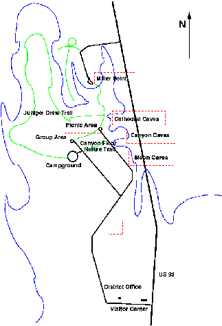
Web sites, guide books, and pamphlets provide maps of the park, but
frankly, I don't think any of these are terribly informative to someone
who hasn't visited this place before. There is a decent map on a sign
at Miller Point, which has been more-or-less reproduced here.
A larger clickable version of the same map can be found toward the bottom
of this page.
The park is situated in a valley (actually, eroded lake bed) maybe 50 to 75 feet below the surrounding area. The elevated area is situated to the north (and east and west) of the blue line on the map. The area inside of this region is the park itself. The region was once at the bottom of a pre-historic lake. Waters flowing into the lake deposited silt which built up of the years. After the lake was gone, water carved channels through the silty layers that made up the region creating the geologic formation that we see today. The eastern edge of the escarpment running from the area marked "Moon Caves" on the map north to Miller point resembles a miniature Bryce Canyon. Here one is able to get up close and personal with the effects of water erosion.
The park is at about 4500-5000 feet of elevation. It's hot in the summer, cold in the winter. From spring through fall I recommend bringing sun protection. I got a little red in April, and I expect that sun block will be mandatory from May to September.
If at all possible, visit during a dry spell rather than soon after it has rained. The ground is very silty and I imagine it will turn into mud when wet. If one does visit after it rains, definitely bring footgear appropriate for muddy conditions, otherwise any shoes one would hike in should be fine. Also, if it's muddy consider bringing a second set of shoes, one for wearing outside the car, one for within.
For those visiting the park for the first time, my recommendation would be to start at Miller point. Miller point sits above the park at the point where seasonal water flows from the surrounding land down the escarpment to carve out the canyons. Because of the elevation, this place provides the best view of the park as a whole, although it provides few clues about the experience of exploring the "caves" below.
From Miller Point one can hike down into the park, but to my untrained eye, it looks like about a 75 foot drop into the park, so if one starts down here, remember that it will be work to get back up. There is a staircase, though, so at least the trip up won't require any significant climbing skills. If one plans to hike this trail, I'd recommend starting from the Picnic Area within the park. This way, if climbing the stairs seems to be more arduous than desired, it won't be necessary to keep going up in order to reach the car again. Further, if one has already been on top of Miller Point, one can save some effort by hiking from the Picnic Area to the base of the stairs (about 1 mile one way by my reckoning) without having to make the climb to experience the view from the top.
Up around Miller Point there is a half mile long trail called Eagle View Trail. I can't say much about it since I didn't hike it.
Entering the park to the south, the first place encountered is the visitor's station. One can pay here (the entry fee is $4 per vehicle for those who aren't camping) or at any of the self-pay locations around the park. Those who pay the entry fee here can obtain a ticket that will allow free admission the same day to any of the other state parks in the area, so that may be convenient. Overnight guests should definitely check in here, and those who plan to do some hiking or climbing and are traveling alone may be well advised to check in as well, so if something happens folks will know someone is missing.
As one drives into the park, I came across a small eroded outcropping of silt stone that I found interesting.
Of course, this is a miniature version of what the rest of the park is like. The silt stone is hard, like a concrete, terra cotta, or adobe, with a coating of dried mud.
Further north, one arrives at the first of three "caves" areas, known as the Moon Caves.
Of course, these aren't caves at all, but small canyons. The largest are easily navigable by a person. Some of them wind quite a ways back into the escarpment. Definitely check some of these out at each of the three significant "cave" sites. Some are more challenging than others, but there is at least one easy one at each of the stops.
These canyons are remarkable, and the best word I can use to describe them is labyrinthine. It's difficult to get the big picture sense of them from within, and I know of no photographs of them from above, although that would be interesting. There's little danger of getting lost, as these are usually one way passages.
The second set of "caves" is called the Canyon Caves.
The big difference between these canyons and those at the Moon Caves site is that here the canyons have more a slope to them rather than the abrupt ends one finds at the other two sites. Therefore, for those who like to climb, here is the place to do it.
Be careful climbing, though. Throughout these canyons are very steep drop-offs that would be, uh, uncomfortable at best to fall into, and could potentially be fatal. The projections are coated with (dried, usually) mud so there are many places where one could easily loose foot or hand holds. Finally, some of the projections are not nearly as solid as they seem. Some have eroded from within and might not be sturdy enough to support a person's weight. Climbing around in here isn't technically challenging compared to, say, climbing the Zion Canyon walls, but one can easily get hurt here, so be cautious.
This is also an exception to the "one way caverns" nature of most of the canyons. At the Canyon Caves there can sometimes be more than one way to get from point A to point B, and one route may be much easier than the other. If one is doing some light climbing, it may be that the route one picks to get out is more challenging than the route used to get in.
The third set of caves is just off the picnic site, and that's the Cathedral Caves.
These canyons seem to me to be more similar in structure to the Moon Caves than the Canyon Caves. It seems to me that there are fewer good places to explore here than the other two, but maybe that's just me. Still, there are some interesting passageways to explore.
This is an excellent jumping off point for the hiking trail that winds through the park. From here hikers can make their way north for about a half mile until they come to a fork. Going east here takes one an additional half mile to the base of Miller's Point. Going west takes one around another 3.5 miles or so around the north edge of the park.
It's entirely possible to do the Miller's Point hike and then return to the picnic area without taking the longer hike. My opinion is that the Miller's Point trip is the more scenic of the two, so someone who wanted to do some hiking should make that part of the trail a priority.
I really enjoyed my visit to Cathedral Gorge State Park, and I recommend it for those who are nature lovers, those interested in natural beauty, or those with an interest in geology. From Las Vegas, a visit to Cathedral Gorge makes an excellent day trip. One can spend a worthwhile two to five hours exploring this place, depending on how much hiking and climbing one wants to do.
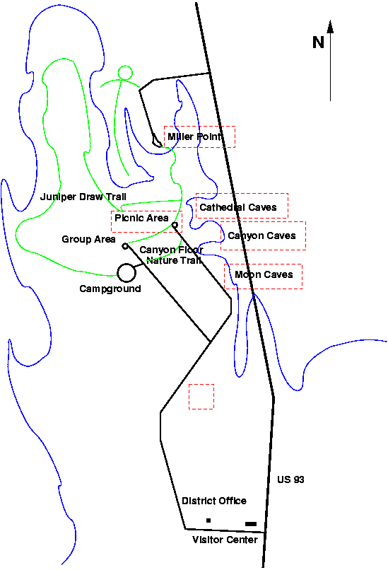
The following map is a larger version of the one that appeared earlier. By clicking within the red dashed rectangles, one can see photos taken at that location.
Copyright Nick Christenson 2007, all rights reserved.